
Water
Resources of Baluchistan
Introduction
The Baluchistan Province
comprising of 32 Districts,
spreads virtually
as a plateau, and area wise is largest Province of the Country. It has boarders with Afghanistan in the North and Iran in the south-west. The characteristic of the
Province are :Area-347,185
Sq. Km constituting about 44% of the Country ; Population
6.566 million as of
1998 census as per population
growth rate the present
day population is about 10.00 million ; Arid with scanty rainfall
varying from 12 to 14 inches in the North to
4to 6 inches per annum
in the South.
- Water Resources
Baluchistan comprises of 44% area of the country. This is the only
Province of the country which has some area outside the Indus catchment .The
north western portion of about 25.822 m acres drains into the Indus. The
remaining area has a separate drainage area. . Kharan Desert, 29.696 m
acres drains into the desert , it isan
area of low lands comprising two lakes, Hamun e Maskhel and Humin e Lora, 73.5 %
area is mountainous . The rest called Makran area drains into the Arabian Sea;
it is 30.272 m acres, with70% mountainous area.
Water resources of the Province are summarized as follow:
, 29.696 m acres , comprising 73.5 %
mountaimus
|
Description
|
Quantity (MAF)
|
||
Available
|
Utilized
|
Balance
|
||
A. Indus Water as per Indus
Accord
|
||||
1
|
Perennial
|
3.870
|
3.052
|
0.820
|
2
|
Flood
|
4.620
|
--
|
4.620
|
Total
|
8.490
|
3.052
|
5.440
|
|
B. Non
Indus Basin
|
||||
1
|
Flood Runoff
|
10.793
|
2.222
|
8.571
|
2
|
Groundwater
|
2.210
|
2.659
|
(-) 0.459
|
Total
|
13.003
|
4.881
|
8.112
|
|
G. Total
|
21.493
|
7.933
|
13.552
|
|
Canal System
In Baluchistan canal supplies are small in total and restricted to the east of the Province, adjacent to Sindh Province. For the period 1988-2000 the average canal flow was 1.94 MAF and recharge from these canals was assessed as 0.29 MAF (15% of 1.94 MAF). Most of irrigated area of this Province lies in a saline groundwater zone. Other components
of groundwater recharge include return flows from irrigation application, other return
flows, sub-surface inflows and
recharge from
rivers. The recharge
from
return flows
of
irrigation application was estimated 0.37 (22.5% of 1.62 MAF) and other return flow was 0.08 MAF (20% of 0.45 MAF).
PatFeeder Canal system was commissioned in 1969, the canal 171 km, distribution length 953 km and has a discharge of
6700 cusecs. The canal system has a command area of 508,425 acres. Kirther Canal System, was built in
1932, the canal is 84 km, whilst the distribution system is 200 km long. The
canals discharge is 2400 cusecs, whilst the command area is 266,000 acres. Uch Canal System was commissioned in 1901;
it is 53 km long, with a discharge of 700 cusecs and a command area of 68,000
acres. Manuthi Canal System was
commissioned in 1909; it is 23 km long with a discharge of 600 cusecs and a
command area of 28,000 acres. Drainage
system is 90 km long, with a discharge of 1200 cusecs, and total drain
length of 1419 km, the catchment area is 555,972 acres.
Dams
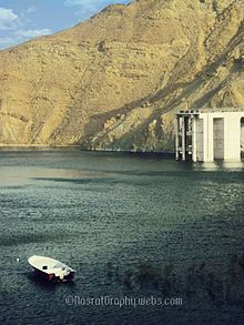
There
have been various attempts to construct dams in the Province Hub Dam was built to supply water to
Karachi and some agriculture use in Baluchistan, is a reservoir on the Hub River. It is situated 56 km from Karachi city in Karachi and Lasbela Districts on Sindh and Baluchistan provinces border. The dam is extended to 24300 acres with
gross storage capacity of 857000 acre feet. It is the Pakistan's third largest
dam. It is an important source that provides the drinking water to the
metropolitan city Karachi.
A dam was built in the Pishin area , called Bund Kushail Khan, in 1990 , this was silted up and is to be
rehabilitated, the dam has a command area of 10000 acres , due to silting its
capacity was reduced from 33800 acre feet to 9000 acre feet . Mirani Dam in
District Kech, on Dasht River south of the Central Makran Range Its 302,000 acre
feet (373,000,000 m ) reservoir is fed by the Kech River and the Nihing River. Mirani Dam was completed in July 2006
and began impounding the Dasht River in August 2006. While the dam is supposed
to irrigate up to 33,200 acres (134 km2) of land according to
official plans, only a fraction of this land is irrigated and developed, On the
night between June 26 & 27, 2007 the backflow water from Mirani dam
inundated upstream areas of Nasirabad, Nodez, and Kallatuk destroying several
thousand houses, date trees, and indigenous underground irrigation
channels. Sabakzai Dam, Zhob District, is an embankment
dam on the Sawar Rud, a tributary of Zhob
River, about 68 km southwest of Zhob in Balochistan, Pakistan.The 395
m long dam is earth and rock-fill with a command area of 7300 acres.
Construction began in 2004 and it was inaugurated on 3 September 2007. The
following are dams are under implementation: Toiwar/Batozai Dam District
killa Saifullah; and Shadi Kaur Dam Pasni
District Gwadar. A phased program of building 100 dams
is also under active consideration. Dams in
the pipeline, WAPDA has prepared
detailed Feasibility Studies of following
dams which are in pipeline for
implementation: Winder
Dam District Lasbella; Hingol Dam District Lasbella;
Noulang Dam District Jhal
Magsi; Garuk Dam District Kharan; Pilar Dam District Awaran; Basol Dam District Gwadar;
and Badanzai Dam District Zhob.
Rivers

The Province has a large number of rivers. The rivers are generally
torrential or empheral which become active for a short period during limited
heavy showers. Some of the streams get absorbed within the land or drain into
depressions. Very few rivers remain active for a long time The River potential is summarized is as follows:
Basin
|
Water Available
|
Water Use
|
Balance Available
|
Dasht River
Basin
|
660
|
83
|
577
|
Gaj River
Basin
|
233
|
25
|
207
|
Gawadar - Ormara
|
546
|
64
|
482
|
Hamun-e-Lora
|
189
|
28
|
161
|
Hamun-e-Mashkel
|
2078
|
312
|
1766
|
Hingol River Basin
|
942
|
136
|
806
|
Hub River
Basin
|
380
|
80
|
300
|
Kachhi Plain
|
1902
|
634
|
On the proballe direction of sub soil floew of water more wells every
1268
|
Kadanai River
Basin
|
77
|
10
|
67
|
Kaha Basin
|
515
|
103
|
413
|
Kand River Basin
|
18
|
2
|
16
|
Kunder River
Basin
|
103
|
27
|
76
|
Mula River
Basin
|
338
|
43
|
295
|
Nari River
Basin
|
817
|
126
|
691
|
Pishin Lora Basin
|
302
|
169
|
133
|
Porali River Basin
|
1106
|
237
|
869
|
Rakhshan River
Basin
|
320
|
34
|
286
|
Zhob River
Basin
|
267
|
110
|
157
|
Balochistan
|
10793
|
2223
|
8570
|
Kareez
Kareez is an
indigenous method of irrigation in which groundwater is tapped by a tunnel.
After running for some distance the tunnel comes out in the open and the water
is conducted to the command area. In Pakistan it is confined to the province of
Baluchistan. Karez is an old and stable irrigation system of Pakistan. It is a
community enterprise managed by tribal tradition and run by social control. Kareez are only utilized in Baluchistan.
Kareez are a underground , sub soil system of water flow ., these have been in
use since last 3000 years and are possibly derived from similar practices in
the Iranian arid lands .The residents mark an area where rainwater drained into
an underground formation and some water appeared a few kilometers down on land
floor . The residents dig a well down to the appearance of groundwater. This
well is called the master well, water from which flows downstream. On a
probable direction of sub soil water flow more wells are dug, every 50 to 100
meters apart. These constructions provide water for years..The discharge is
between 0.5 cusecs to 3 cusecs. Water from kareez is dwindling mainly because
of the use of tube wells
The indigenous management of systems predicated upon extremes.
In Baluchistan, we have 6,000 years of cultural knowledge of droughts. Unfortunately,
these indigenous systems of providing water have been replaced by unsustainable tube wells. The tube
wells have sucked all the water out of the traditional karez system and have
only made a few farmers rich while many others have become paupers. In fact,
there has been a lot of migration from the area over time as smaller farmers lost their orchards,
their status and their identity.
Groundwater Potential in Baluchistan
Pakistan’s major
groundwater resource
is in
the irrigated areas
of
the Indus Basin, while
the second source
lies
in the areas outside the Indus
Basin.
. The groundwater outside Indus Basin is in Baluchistan province, where the recharge source is mainly precipitation
i
The regions of the Province, which are underlain by unconsolidated sediments formed by the deposition of mountainous outwash from the surrounding highlands, have been divided into 12 distinct Basins, flood plains
and valleys fills. The Province lies in the five hydrological zones namely, Mountain ranges, Piedmont plains,
Valley floor, plains and rolling sand plains. The groundwater, in substantial quantities, occurs in unconsolidated
aquifers in almost all basins and sub-basins. The groundwater resources in six basins of the province namely Hamune, Lora,
Kachhi Plain, Nari, Pishin and Zhob have been assessed. The effective rainfall coefficient of
20% to the annual rainfall for the mountain
areas
is used
to estimate rainfall of 1.21 MAF.
Water formations of
the Province cab be divided into three parts ,About 70% area is mountainous ,
at the foot of the mountain starts a formation build by deposition of fissured,
disintegrated and fragmented rocks transported by water . This formation
contains layers of gravel, deposits of varitypes types of sand and clay lenses
.Its permeability is high. It is water saturated to various depths. The surface
floor is generally steep and near its end start finer deposits of clayey types,
this has low permeability and water is found at shallow depths .There are many
such valleys , these sources of water
have been used since long . The total groundwater resource of Baluchistan
Province was assessed as
2.13 MAF.
The Groundwater is extracted through open surface shallow wells as well as through deep tube wells .However the groundwater resources have extensively and indiscriminately been exploited during the past three decades which has seriously damaged the quantity and quality
of the ground water aquifer
resulting into the sharp annual depletion ranging
from 1‐3 meter in different water basins of the Province. The Provincial Government is taking
remedial measures to augment the ground water table through adopting ground water recharge measures, ban on installation of new tube wells and capping of the subsidy on already installed tube wells.
Plans have been formulated to meaning full harvesting of huge flood water through construction of surface
water body to
shift acute pressure from ground water resource to the surface water bodies. In
Baluchistan Province present groundwater abstraction has been estimated 0.45 MAF by about 24 000
private tube wells. The average capacity is 0.3 cusecs of private tube wells and 0.18 cusecs of pumped dug wells (ACE and Halcrow, 2001).
Year
|
|||
Number
|
Annual
Increase
|
||
1965
|
470
|
||
1966
|
650
|
180
|
|
1967
|
870
|
220
|
|
1968
|
1075
|
205
|
|
1969
|
1285
|
210
|
|
1970
|
1870
|
585
|
|
1971
|
2278
|
408
|
|
1972
|
2521
|
243
|
|
1973
|
3040
|
519
|
|
1974
|
3646
|
606
|
|
1975
|
4262
|
616
|
|
1976
|
4631
|
369
|
|
1977
|
4863
|
232
|
|
1978
|
5143
|
280
|
|
1979
|
5954
|
811
|
|
1980
|
6453
|
499
|
|
1981
|
7033
|
580
|
|
1982
|
7458
|
420
|
|
1983
|
7691
|
238
|
|
1984
|
7997
|
306
|
|
1985
|
7887
|
110
|
|
1986
|
7952
|
85
|
|
1990
|
11000
|
762
|
|
1995
|
17000
|
1200
|
|
2000
|
24000
|
1400
|
|
QESCO
statistics report that by the end of FY 2015 there were 31139 electric tube
wells in the Province.
Ground Water
Balance
In certain areas of the province of Punjab and Baluchistan mining of groundwater has
aggravated the situation. The water balance in Baluchistan
presented as follows:
Parameters
|
Baluchistan
(MAF)
|
Rainfall Recharge
|
1.21
|
Recharge from Canal System
|
0.29
|
Return flow from irrigation
|
0.37
|
Domestic & industrial return flows
|
|
Other return flows
|
0.08
|
Recharge from Rivers
|
0.18
|
Total
|
2.13
|
Groundwater Abstraction (Private, STWs
&
PTWs)
|
0.45
|
Groundwater Abstraction (domestic &
industrial)
|
|
Non-beneficial
ET losses
|
1.13
|
Sub-surface Outflow/change
in GW
|
0.41
|
Base
flow
to Rivers
|
0.14
|
Total
|
2.13
|
The
above Table reveals that the groundwater resources for Baluchistan are 2.13 MAF. About 0.45 of groundwater is being
extracted. This indicates that a groundwater potential of 1.69 MAF is more available for the Province. However, 0.67
MAF of that potential resource is linked to the canal system in the east of the Province where the groundwater is generally saline. The remaining potential for the rest of the Province is 1.02 MAF. The sustainable groundwater development in the Province is 0.64 MAF (ACE and Halcrow, 2001), with 50% of this
potential located in two basins of Porali and Hingol. The situation has worsened in a number of sub-basins since 1996 as the uncontrolled development of groundwater
in the Province was allowed to continue. Some sub-basins
within the Province (Quetta, Mastung, Mangochar and Pishin in the Pishin-Lora basin, Loralai, and Duki in the Nari
basin) are rapidly approaching a catastrophic state in terms of groundwater resources and urgent action is
needed to prevent. Thousands acres growing garden and vegetable crops in Loralai Basin have become barren
due to the drying up of the aquifer.
Ground Water Management
One of the reasons for higher exploitation of groundwater was the flat-rate cost
of energy charged to
the farmers. Therefore, it is
necessary that
energy charges should
be proportional to the actual
use of energy. Because of the absence
of groundwater management in the
private sector, anyone can install a tubewell
anywhere in his land and can extract whatever amount of water he wants any time without consideration of the
detrimental effect of his action on the resource. If the pumping is equal to recharge rate for a sufficient period
of time, the watertable depth will stabilize somewhere below the ground surface. In cases where the pumping of
groundwater is in excess to the potential recharge rate, the mining of the aquifer will result in the accelerated depletion of the groundwater resource with an unsustainable lowering of the water table. Also, the uneven groundwater development and pumping through private tubewells has started showing
stress on the aquifer in the form of excessive draw-down and deterioration of groundwater quality. This requires serious attention and the urgent adoption of measures for
proper groundwater management.
A groundwater regulatory framework should be introduced and implemented for the sustainability of
groundwater use. Recharge of groundwater should be increased by increasing canal diversions, rainwater harvesting and check dams.
Continuous over-draft in excess of the
average annual recharge has been resulting in the knocking out of
shallow pumping wells. More pumping in relatively dry years, like nowadays, is causing excessive draw down in certain
areas. As a result, at the present time, about 5% area of Punjab Province and 15% of Baluchistan contains groundwater which is out of the reach of the poor farmers. This is likely to increase to 20% in Punjab and 30% in Baluchistan in the next 25 years,
with the present growth of groundwater withdrawals and unsystematic
pumping of fresh groundwater due to abnormal lowering of the water table and an increase in areas adjoining
saline zones. In an effort to manage the increasing demand for water, low water delta crops should be preferred
on high delta crops and more efficient irrigation methods should be used. In addition, there is a large area of the Indus Basin which has marginal and saline groundwater. This water can be used for saline agro-forestry and alternative agricultural crops.

Conclusions related to ground water
1. Groundwater has become a major source of water supply in Pakistan
2. Excessive
use of groundwater is
causing secondary salinisation
3. The situation has
worsened in a number of sub-basins in Baluchistan
Province
due to groundwater mining
4. Continuous over-draft has resulted in excessive groundwater abstraction
15% of Baluchistan
Province contain
groundwater out
of
reach of poor farmers
5. There is
a need to realistically estimate
and manage the demand for
water
6. The flat-rate energy charge has encouraged farmers to exploit more and more groundwater, which has
resulted in an unsustainable situation.
Recommendations related to ground water
1. A groundwater
regulatory framework should be introduced and implemented
for the
sustainability of groundwater use
2. There is
need to manage the demand
of water
3. Low water delta crops should
be preferred to high delta crops
4. Efficient irrigation
methods should be used to irrigate crops
5. Recharge of groundwater should be increased by increasing canal diversions, rainwater harvesting and check
dams
6. Saline
water
can be used for saline agro-forestry or for
alternative agricultural crops
7. Energy charges should be proportional to
the use of energy for tube wells
8. Research on
groundwater recharge
is urgently required.

Proposed Quetta Project
Quetta
city is located in a valley of about 700 sq. miles, It us circumcised by ranges
of dry mountains at the foot of which exists the flat residential land. The
valley receives 8.75 inches of rain every year; about seven months are
completely dry .The whole area has no perennial source of water. Ground water
has always been the main source of supply Attempts have been made to construct
storages and to divert rain water in the near past an underground aquifer was
discovered which was used to supply Quetta City this also is now nearing
depletion and the water supply to Quetta City is seriously threatened.
The government of Baluchistan intends to embark upon an
ambitious plan of providing water to Quetta from Pat Feeder and Kachhi canals
through a 271-km-long pipeline The total cost of the project has been
estimated at Rs40 billion (56 per cent of the current Public Sector
Development Plan Rs 71bn) and it is scheduled for completion in three years.
The pipeline, with a diameter of 56 inches, will run from Naseerabad to Quetta. It will pass through the districts of Lahri, Sibi, Kachhi and Mastung areas which feature plains as well as mountainous terrain. The project envisages pumping of 120 cusecs of water with the help of eight pumping stations from a height of 350 to 7,000 feet above sea level. Another question, and a technical one, is that how 120 cusecs will be pumped from a height of 350 feet to a height of 7,000ft with the help of eight power stations on different sites. the pumping stations will either be powered with the help of fuel-fired generators or solar energy or a separate power house having a capacity of 100 megawatts will have to be set up. Sixty million gallons of water per day (MGD) are needed for Quetta`s two million people while the combined projected output of the three dams would be, at best, 35MGD.
Artificial
Recharge
.Groundwater recharge or deep drainage or deep percolation is a hydrologic process where water moves downward from surface water to groundwater. Recharge is the
primary method through which water enters an aquifer. This process usually
occurs in the vadose
zone
below plant roots and is often expressed
as a flux to the water table surface. Recharge
occurs both naturally (through the water cycle) and through
anthropogenic processes (i.e., "artificial groundwater recharge"),
where rainwater and or reclaimed water is routed to the
subsurface. If waterfalls uniformly over a field such that field capacity of the soil is not
exceeded, then negligible water percolates to groundwater. If instead water
puddles in low-lying areas, the same water volume concentrated over a smaller
area may exceed field capacity resulting in water that percolates down to
recharge groundwater. The larger the relative contributing runoff area is,
the more focused infiltration is. The recurring process of water that falls
relatively uniformly over an area, flowing to groundwater selectively under
surface depressions is depression focused recharge. Water tables rise under
such depressions.
The sediment content of Baluchistan Rivers is very high, clay
and silt forms more than 50% to 90% of the sediment transport.. High clay and
silt are harmful for storages and dams .Construction f check dams were
utilized in Baluchistan to recharge the ground water. The main purpose of
these delay action dams wd to store rain and flood water , which over time
percolated into the groundwater formations .Large number of such dams were
constructed , these functioned well in the first few years but then were
clogged by the high silt and clay load
. Another method tried was to spread surface water thinly so as to recharge
the underground storage, this also did not work well
Building multiple storages on the same river is suggested also suggested is to have a main dam which would be clogged n-but a side opening allowed water to be stored in a side storage facility .
Reuse
of waste Water
Quetta
valley needs to consider the use of treated and recycled waste water. Reclaimed or recycled
water is the process of converting wastewater into
water that can be reused for other purposes. Reuse may include irrigation of
gardens and agricultural fields or replenishing surface
water and groundwater (i.e., groundwater recharge).
Reused water may also be directed toward fulfilling certain needs in
residences (e.g. toilet flushing), businesses, and
industry, and could even be treated to reach drinking
water standards. This last option is called either "direct potable
reuse" or "indirect potable" reuse, depending on the approach
used. Colloquially, the term "toilet to tap" also refers to potable
reuse.
Reclaiming water for reuse applications instead
of using freshwater supplies can be a
water-saving measure. When used water is eventually discharged back into
natural water sources, it can still have benefits to ecosystems, improving
stream flow, nourishing plant life and recharging aquifers, as
part of the natural water cycle
Wastewater reuse is a long-established practice
used for irrigation, especially in arid
countries. Reusing wastewater as part of sustainable water
management allows water to remain as an alternative water
source for human activities. This can reduce scarcity and
alleviate pressures on groundwater and other natural water bodies
Wastewater treatment typically
includes preliminary treatment steps in addition to primary and secondary
treatment. Preliminary steps include measuring the flow coming into the
plant, screening out large solid materials, and grit removal to protect
equipment against unnecessary wear. Primary treatment targets settle able
matter and scum that floats to the surface
Secondary treatment processes are
employed to remove total suspended solids, dissolved organic matter (measured
as biochemical oxygen demand), and, with increasing frequency, nutrients.
Secondary treatment processes usually consist of aerated activated sludge
basins with return activated sludge or fixed-media filters with recycle flow
(e.g., trickling filters; rotating bio-contactors), followed by final solids
separation via settling or membrane filtration and disinfection
Advances over the past 20 years in
membrane bioreactor (MBR) technologies have resulted in an alternative to
conventional activated sludge processes
|
Reasons for water scarcity

The
reasons for water scaricity are : Geographic Location
;Low Rainfall ;Geo-Morphological Characteristics
; Global Warming
Climate Change &
its Impacts (Drought, Flooding Sea level raise) ; Poor Watershed
Management / Watershed degradation.
; Traditional Cropping
Pattern / Irrigation Systems (Flooding of field)
; Rapid Growth in Population/Urbanization
; Poor Mass-Awareness ; Poor legislative frame
works and its Implementation.
Water availability in Baluchistan has always been remained deficient
against the demand,
as per UN standers
availability of 30 gallon water per capita is ideal arrangement but in Baluchistan hardly 10 gallon
of water per capita
is being made available to about
60%
of population. In-efficient
use of the available surface water resources, in-discriminate exploitation of the ground water, wastage
of heavy flood water,
watershed degradation, coupled with the phenomenon
of climate change leading
to
extreme events of flood and drought has made water
management a difficult mandate.
Despite huge interventions in water sector, population growth
urbanization, development of the mining, industrial sector
and expansion in agriculture activities the water demand has increased,
putting great stress on the water resources
of the province which are
otherwise in deficit
due to peculiar
environment of the region.
The province of
Baluchistan has suffered
long drought spell of 8 years
from 1997-2005 and also three continual
high intensity cyclonic,
river an and excessive rain floods in 2007 2010, 2012 having divesting impacts on all
social sectors but
more pronounced on water sector.
Steps needed to
be taken
Since attaining provincial status, no water policy could have been formulated,
The
province needs to ensure adequate and sustainable water resources
(by 2030) through holistic development and efficient management of
available and new water resources. Activities and steps that are
needed to be taken are :
Rain water
harvesting through efficient water
shed management.
Ban on uncontrolled
with drawl of ground water.
Improvised cropping
pattern, suiting
to environment and Water situation of the Province.
Use of
spate Irrigation (Sailaba and Khushkaba).
Introduction of efficient irrigation technology.
Efficient plan and development of water budget to meet the requirement of different sectors
as actual requirements basis
Check on massive Rural Migration to Urban Centers
Check on development and industrialization in the Piedmont Region of the Valleys
Behavioral Change
in the Community.
Effective measures against
water losses and
equitable
distribution of water
amongst beneficiaries.
Identification of technically feasible and economically viable and
community oriented
schemes through professionals and timely
completion of the projects
for effective harnessing and dividend
generation from water recourses.
Institutional reforms and capacity
building to make the
organization and professionals equally dynamic and responsive
future challenges ahead for assured sustainability of water
resources
Address of Inter Provincial Water related
issues (water sharing, drainage and flood related
issues).
Institutional reforms,
capacity building through
advance learning and research
at all the levels stakeholders to ensure, effective
response against the challenges
Water
Policy
The provincial Irrigation Department has formulated the provincial
water policy the basic documents of water policy are approved by Provincial Cabinet. However unfortunately the same is not
transformed into an Act.
The
policy is aimed at to achieve the fallowing aims and
objectives.
Efficient conservation and management of the available water resources.
Maximum harnessing of the flood and rain water through efficient
water shed management
and development of surface water
bodies.
Efficient Ground Water recharge measures
to arrest sharp depleting ground water levels
Quetta, especially in Pishin Lora, Nari and Porali basins.
Increase of ground
water exploitation in the areas of Dasht,
Rakhshan, Human Mashkhail and Hingol river basins where potential exist
Steps Initiated
The Federal government through the efforts
of Provincial Government
has
approved a PC-II for detailed
feasibility study of water resource development through
construction of Medium Storage Dams in
Balochistan and allocated Rs.100.0
million in the Federal PSDP for financial year 2013-14. Consultants are being
hired
Consultants have been hired to undertake
Detailed Feasibility Study for construction of Dispersal
Structures on Zhob River for gainful utilization of huge quantity of water which is being wasted due to the
non availability of infrastructures. As a result of Detailed Survey/Investigation a Proposal for Construction of Dispersal
Structures of Zhob River costing
Rs.10.0 Billion have been prepared
and being processed
for approval of the competent authority.

The World Bank financed
Project BSSIP (Baluchistan Small Scale Irrigation Project) has already engaged consultants for the detailed
feasibilities of integrated water resource
management of Nari and
Porali Basins at a cost of Rs.17.0 Billion and
13.5 Billion respectively.
The PID Baluchistan has recently rehabilitated 15 karezes in District
Pishin, Killa Abdullah,
Mastung and Kalat Districts through a World
Bank financed Baluchistan Small Scale Irrigation Project (BSSIP) at a cost of Rs.550/- million with cleaning, extension, lining of conveyance
system and construction of check dams upstream to help recharge
of the karez
Rain water harvesting
The growing demand of water against the scarce water resources is the one of the biggest challenge of 21st Century as the regular water supplies through conventional system is on decline and rain water harvesting can thus prove as an important alternative and supplementary resource.
Through efficient
rain water harvesting practices the short supplies can be augmented both in the rural and urban centers.

Rain water harvesting is low cost simple technique easily practicable with to supplement the scarce water resources and as
a better alternative against the brackish ground
and polluted surface water.. In the arid and semi arid region the rain water practices are rather more important to collect
it as efficiently as possible otherwise the rain water resource
available may be lost through surface
run off and evaporation
During the past decades the rain water harvesting is actively introduces in the rural
and urban areas and as gainpopularity being accessible, affordable and relatively clean source at the domestic / local level.
Owing to the pollution
of ground water and surface water,
water scarcity, increase in the population the available water resources
are dying up as such the communities
have to tune up themselves to new resources
through rain water harvesting practices.
Rain water harvesting practices are observed
as of great importance in the arid and semi arid regions and in the areas of small coral volcanic islands,
remote and scattered
human settlements
Rain
water harvesting is defined as method of inducing,
collecting, storing and conserving local runoff for house hold, drinking,
livestock as well as for small scale agricultural activities in
the arid
and semi arid regions. The
rain water harvesting practices are mostly adopted
practiced in the arid and
semi arid zones with the limited annual
rain fall, where rain water harvesting i.e. use of surface
runoff can
be a potential source to supplement to address water scarcity
issues.
Rain water harvesting in the arid and semi arid region is illustrated
by
micro catchment area measuring few hundred square meter with adjacent basin
area where runoff is stored
and conserved for consumption of trees and bushes and also for the consumption
of small local
population.
Rain water harvesting technology is quite simple for collecting
rain water from roof tops catchment, land surface catchment with the conveyance system for transfer of rain water to be collected in the storage tank
In different parts of Asia the Governmental and non-government Organization are involved in rain water harvesting particularly in Thailand and Philippine both the Governmental and community organization as well as through house old based initiatives the use of rainwater harvesting technology is expended particularly in the water scare region
Rain water harvesting is accepted has viable
practice for augmentation of fresh water as the bacteriological contents
of the rain water collected from the small catchment is less and also the quality of water harvested from the properly
maintained roof tops catchment connected with the storage tank having better
covers is preferable for drinking
purposes as such rain water harvesting practices are widely acceptable.
Rain water harvesting is equally
suitable in the urban as well as rural areas at its augments Municipal Water Supply for house hold and drinking
water purposes as
it
does not requires highly
skill manpower .
The rain water
harvesting technology and practices are highly cost effective
which depend of the type of catchment, conveyance
and storage tank and material used.The cost of rain harvesting technology and arrangements is for less than cost
involve in the development of shallow dug wells, tube wells and also does
not involve huge O&M cost;
The feasibility and efficiency of the rain water system harvesting in a particular locality depends on the amount and intensity of the rain,
the
length of catchment
area and the gradient/slops of the micro catchment area.
These variables can however
be adjusted according
to the house hold
requirement and
needs in particular area
Benefits
The benefits of rainwater harvesting include : Improvement in the quality of ground water;
Rise in the water levels in the wells and bore wells that are drying up; Mitigation of the effects of drought;
Attainment of drought proofing; An ideal solution to water problems in areas
having inadequate water resources; Reduction in the soil erosion as the surface runoff is reduces; Decrease in the choking of storm drains and flooding
of roads ;Saving of energy to lift ground water (one meter rise in water level saves 0.4 Kilowatt hour of electricity); rain water harvesting technology are simple to install and operate; Common people particularly in the rural area can be easily trained in the rain water harvesting
practices. The construction material
required are cheap and radials available and it is convents
that it provides
water for consumption at the spot; The
maintenance is also quite cheap and simple which involves
periodic cleaning of the tanks regular inspection of the conveyance system;
The main objectives of rain water harvesting is purposeful utilization of available rain water to meet the local requirements without much
financial implications; Rain water practices are highly helpful in the areas facing water scarcity
and facing threats
of drought or drought
like situation ;Rain /flood
water harvesting reduces the cast of portable
water being less cost incentive; Rain flood water harvesting reduces
pressure on already
under stress ground water resources
and raises ground water table ; Soil erosion due to heavy flesh floods in the river bed can be reduced
through rain/flood water harvesting
;Rain water harvesting reduces accumulation of salt in the soil which is harmful to the growth of plants
and allow better root growth and also
increases drought resistance in plants.
Disadvantages
Rain water harvesting has benefits but there are also some aspects
that need attention, these are: The major disadvantage to the rain water harvesting technology is the limited and un-certain rain falls;
the
technology assists
the poorer sections of society
who are unable to attract the attention of authorities; Ground slopes are main limitations defeating efficient rain/flood water harvesting in
particular areas of high/medium altitude
mountain ranges where gradient/slope is high, greater than
5%; In the areas with uneven
surface and uneven
distribution of runoff huge earth works get involve
having financial implications hence unfeasible for the local formers;
The texture of the soil of the local area is again very important, soil with high
quantity of sand and gravel the most permeable
formations allow high infiltration as compare to the intensity
and number/intervals of rains and runoff.
Rain harvesting possibility in Baluchistan
The rain water harvesting possibilities in Baluchistan is influence by
the following factors : The climate of the province ranges from semi arid to arid with extreme variation in the temperature , the mean annual precipitation varies from
less 50mm to more than 400mm in the valley;
Most of the precipitation is received in the higher mountain during the
winter between 250 mm to 350mm;
Due to high gradient and slopes the rain water usually
flow in flesh
down the stream and as such rainwater
harvesting practices are opted
in the low plains mainly through construction of micro bundates
and pit holes for the limited local consumption of nomadic
population; In the given geographical, geomorphologic and climatic
conditions the rain water and flood water harvesting are more relevant
and important in the context of the province which facing
serious challenges of water scarcity for progression in
different social sectors; Due to limited
rains and deficient availability of surface and under ground water resources out of 30.00 million acre cultivable land only 4 .00 million acre of land is put under cultivation which hardly 7% of the geographical area of the province
44%; Out of total cultivated area of 4.00 million acre 47% of the cultivable land is irrigated whereas
53% of the remaining cultivable land is under Sailaba and Khuskaba irrigation using flood and rain water resources;
The land under Khuskaba
farming is 0.26 million ha about 12% of the total cultivated land; Khuskaba irrigation is traditional system of farming
irrigated through local runoff from the adjacent catchment;
In the centre and north-east of
Baluchistan Province seven districts are defined as highland rained areas.
These districts
are
Quetta, Kalat, Pishin, Loralai, Zhob, Kachi and Khuzdar
. these have a total geographical area of 14.9 million
hectares; In Balochistan, runoff farming
system in named as Khushkaba and it goes back as early
as 3000 BC and provided economic basis for some of the early civilizations; These systems are
located in highlands of Khurasan
Range, on eastern slopes of Suleiman Range and Central Brahui Range which are characterized as temperate, where precipitation is gentle and spread over
a longer period; Rain fed Khushkaba system depends upon
direct rains. The farmers sometimes develop a small catchment
area on upper side of the field and the rainwater
is harvested for farming
on the lower side; sometimes no catchment
area exists
and the water is directly
harvested in the cultivation fields;
The major agricultural crops of these
rain fed districts are wheat, tobacco, potato, apple, grape and barley. Farming in the district is
mostly rained (Barani); The scarcity
of water
in these
district calls for adopting comprehensive water harvesting and management strategies,
in order to meet the demands for agricultural and domestic
water needs, which can be met through;
Rain Water Harvesting for storage for future local / domestic use; Rain
Water Harvesting as Ground Water Recharge
measures; The Rain water is so harvested
by adopting traditional techniques and construction of surface and underground structures.
Rain Water schemes implemented
The Provincial Irrigation Department has undertaken different projects
for rain water harvesting at the cost of Rs.369.00
million for the last three years
with the details as
below:-
S
#
|
Fin. Year
|
Name of Scheme
|
No
|
.Cost (Rs.M)
|
1
|
2010-11
|
Construction of MICRO
Bandat for Agriculture District Harnai
|
50
|
30.00
|
2
|
2010-11
|
Strengthening and raising of Zamindara MICRO
Bandat in Dureji area District
Lasbella
|
10
|
10.00
|
3
|
2011-12
|
Construction of Small MICRO
Bandats at
District Gwader
|
100
|
100.00
|
4
|
2012-13
|
Construction of MICRO
Bandats District Musa Khail
|
60
|
65.00
|
5
|
2012-13
|
Small Irrigation Schemes (Bandats)
in Musa Khail
|
140
|
153.985
|
6
|
2013-14
|
Construction of MICRO Bandats District Kech
|
130
|
149.00
|
7
|
2013-14
|
Constt: of MICRO Zamnidara Bandats District Kech
|
20
|
15.40
|
8
|
2013-14
|
Construction of MICRO District Jhal Magsi
|
50
|
60.00
|
Total:
|
560
|
583.385
|
||
Baluchistan Experience with Recharge Efforts

Groundwater mining in Baluchistan is recognized to be a very serious
problem facing the water sector. It is therefore
not surprising that numerous efforts
have been undertaken to cope with the
alarming situation of depleting water tables. A number of projects have been undertaken in the
past. A very promising and good project was the Zargai Recharge Project established by
Balochistan Minor Irrigation and Agricultural Development Project to evaluate the viability, both technical and economic of the off-line aquifer
recharge scheme. It consisted of three
components, a diversion structure, a storage reservoir
and a recharge area. The recharge area consisted, of a series of zigzag channels
through which the rainwater flows slowly and with time
infiltrating into the ground.
Results
of the study indicated that infiltration is related to the depth of ponding and that the
optimal depth of ponded water to maximize
the recharged is 150 cms. It was found that a net yearly infiltration volume of 120 cm takes 10 years to reach a 100-meter deep
groundwater table in a silty loam soil, but only 5 years in the same soil with 60% stones. It was concluded
that the artificial recharge schemes in Baluchistan had an insignificant impact upon falling of groundwater
levels, and were likely
to contribute, an amount of additional water capable of supporting less than 1.5% of the existing orchards in the project area. The project is now dead.
The experience with delay action dams, an excellent technique, has not been a very good one. The high amounts
of sediments and silt load brought in by the feeding
streams in the reservoirs has been the major factor in reducing the effectiveness of the dams as sources of recharge. It is essential that the dam design may be radically revised to include provisions for allowing water escapes on the downstream side of the dam body to recharge the bed of the stream. In the existing dams provision for releasing water
can still be provided by installing
siphon tubes system on each
dam.
Watershed
management is another area where little has been done in the province. Major efforts
are required to undertake
watershed management works in potential areas with adequate
soil covers. All future dam projects must have adequate provision for watershed management.

It remains
to be seen how effective
the recent efforts
to recharge aquifers
in Baluchistan by constructing leaky dam (as done by PCRWR near Quetta) are successful. It is
however, essential that an integrated approach be made to recharge and conserve water.
Update Jan., 4, 2019: